Railway Expansion through Precise Drone Mapping: PIE’s Contribution in Indian Railways
October 22, 2024

Aerial photography is a thing of drones now! Back then, aerial photography was used primarily for military assistance and remote sensing in geology and geography. Flash forward to now, the introduction of drones over the past few years has further zoomed in on the usage of aerial photography almost everywhere, even in agriculture, infrastructure, and environmental monitoring.
Indian Railways, like agriculture, is an integral part of shaping India’s culture, economy, and society—offering a safer and more reliable transportation system.
Safer Indian Railways are crucial for the nation’s progress and well-being. They indeed contribute to the preservation of heritage, promote trade and industry, and improve the quality of life for millions of people. Wait! Wait! You didn’t misread the blog title. It is still about drone mapping.
PIE’s Drone Mapping Technology: A Game-Changer for Indian Railways
Understanding the profound significance of Indian railways, PIE backs up the mission of safer railways with Precise Drone Mapping Technology.
No more yapping about Indian Railways. Let’s get straight into the blog’s topic.
Project Broad Gauge railway line around Visakhapatnam and the interior hilly regions of South East India:
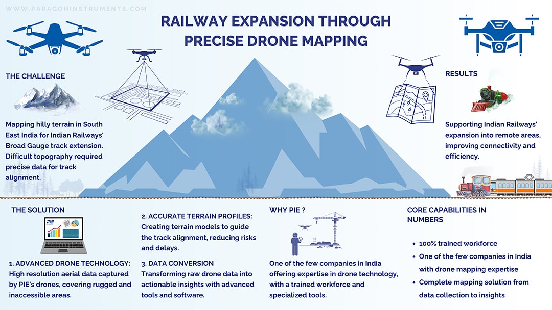
Modern infrastructure projects in challenging terrain need precise data to direct every step of the process, alongside advanced technologies. In India, in particular, the development of railway networks is a must for connecting remote regions. PIE stepped into a railway project the moment it needed precise data. The great project by Indian Railways to build a Broad Gauge railway line around the areas of Visakhapatnam and interior hilly regions of South East India required accurate data creation and visualization.
Challenges in surveying hilly terrains
Surveyors involved in this line of work are required to have a thorough knowledge of the area. Accurate terrain profiles are essential to identify the best possible railway alignment before installing even a single track.
How PIE addressed surveying challenges
PIE used its drone mapping technology to provide a solution to the challenges associated with surveying rough, uneven landscapes.
The task was not easy—mapping the hilly terrain of South East India presents unique challenges due to its complicated topography. Traditional surveying methods would have been time-consuming, less accurate, and hazardous in such an environment.
Data collection and visualization for accurate decision-making
Even in locations that were challenging to reach on foot, we captured detailed, high-resolution aerial data using our advanced drone technology. This data, combined with inputs from other survey methods, was used to create a composite terrain model. With this model, engineers will now be able to design the railway alignment. By providing accurate terrain profiles, PIE has helped reduce the risks of costly design errors and construction delays, ensuring the railway’s extension could proceed safely and efficiently.
You can presume now that we didn’t stop with just data collection. Yes, additionally, we addressed the problem of how to transform raw drone inputs into concrete, usable data. The visualization part!
We have helped the engineers with the apt graphical processed images of the collected data of the terrain layouts. We are proud that we are enabling the Indian Railways team to make well-informed decisions with actionable analytics and insights in hand only with the support of PIE’s expertise and tools.
Building a Connected Future with PIE
Very few companies in India have the capability to handle such projects from start to finish. At PIE, our specialized equipment and qualified manpower enable us to operate drones in challenging environments and provide meaningful data to support bigger infrastructure projects like these. By offering reliable surveying solutions, we are helping Indian Railways make progress in its efforts to connect more regions, improving both transportation and economic opportunities in the process.
PIE in 2024 is not just solving a technical problem—we are helping to create the foundation for a more connected future where infrastructure development can proceed with confidence, guided by the accuracy and precision promised by us.
Consider it a wise choice when choosing PIE as your project partner.
FAQs
What role does drone mapping play in Indian Railways’ expansion projects?
Drone mapping provides high-resolution, accurate aerial data that is essential for infrastructure projects like railway expansion. In the case of Indian Railways, it helps survey challenging terrains like the hilly regions of Visakhapatnam. This technology enables engineers to create precise terrain models, reducing the risk of design errors, construction delays, and ensuring that the railway lines are safely and efficiently planned.
How did PIE contribute to the Visakhapatnam Broad Gauge Railway Line project?
PIE used advanced drone mapping technology to survey the rough terrain of the Visakhapatnam region, offering detailed and accurate data. The data was used to create composite terrain models, helping engineers identify the best possible railway alignment. PIE’s involvement helped mitigate the risks of costly errors and delays, providing crucial data for the safe and efficient expansion of the railway network in challenging environments.
What challenges were faced while surveying the hilly terrain of South East India?
The hilly terrain in South East India presents several challenges, including uneven landscapes, difficult access, and complicated topography. Traditional surveying methods would have been less accurate, more time-consuming, and even dangerous. By using drones, PIE was able to overcome these challenges, providing high-resolution aerial data even from areas that were difficult to reach on foot, making the surveying process safer and faster.
How does drone technology improve the accuracy and efficiency of railway projects?
Drone technology allows for the collection of high-resolution, detail ed aerial data that traditional surveying methods might miss. This data helps engineers create precise terrain profiles, which are crucial for railway alignment and construction. The ability to gather data from difficult-to-reach areas and create 3D models reduces the risks of errors and delays, improving both the accuracy and efficiency of infrastructure projects like railway expansions.
What makes PIE a unique partner for infrastructure development projects in India?
PIE stands out due to its ability to handle infrastructure projects from data collection to actionable insights. With specialized equipment and highly qualified manpower, PIE can operate drones in challenging environments, providing precise data for infrastructure projects like railways. By offering end-to-end solutions, PIE enables infrastructure development to proceed with confidence, ensuring that projects are safe, efficient, and economically beneficial.


