How to choose the right surveying instrument for field deployment in North India?
March 17, 2026

Choosing the right survey instrument affects measurement accuracy, project speed, cost, and risk of delays. In most parts of North India( Delhi NCR, Jaipur, Chandigarh, Lucknow, and surrounding regions) – survey teams face high heat (45°C+), dust, humidity, and urban canyons in metros. These external factors are major challenges affecting both optical and GNSS instrumentation. This guide simplifies how to select the right tool for every major project type and budget.
Paragon Instrumentation Engineers Pvt. Ltd. offers a wide range of surveying and construction instruments from world-renowned brands like Sokkia and Geo-Fennel , with prompt service support and rapid calibration services across North India.
Main Survey Instrument Categories and When to Use Them
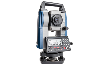
Total Stations
Total Stations are optical instruments that measure both angles and distances electronically and compute coordinates in real-time. They combine an Electronic Distance Measurement (EDM) system with an electronic theodolite.
- Building & facility layout
- Road and bridge control points
- Industrial plant surveys
- Metro and rail projects
- Cadastral and boundary surveys
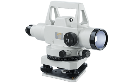
Automatic Levels
Automatic Levels determine height differences between points using a self-leveling compensator and are the most cost-effective solution for vertical measurement.
- Earthwork grading
- Benchmarks & slope checks
- Road formation levels
- Construction site leveling
- Canal and drainage projects
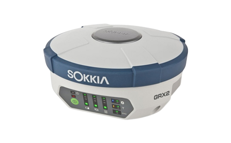
GNSS RTK Receivers
GNSS RTK (Real-Time Kinematic) systems receive signals from multiple satellite constellations (GPS, GLONASS, Galileo, BeiDou , IRNSS ) to provide centimeter-level positioning accuracy.
- Large open area mapping
- Highway/rail corridors
- Solar/wind farms
- Topographic surveys
- Long linear projects
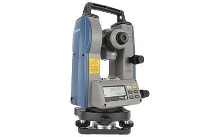
Electronic Theodolites
Electronic Theodolites measure vertical and horizontal angles with digital readouts and data storage capabilities.
- Control network setup
- Angular measurements where distance is not required
- Vertical alignment checks
- Tunnel and shaft alignment
Accuracy, Use Case, and Cost Levels
| Instrument | Measures | Typical Accuracy* | Best Project Use | Relative Cost |
|---|---|---|---|---|
| Automatic Level | Heights only | ±1.5–2.5 mm/km | Earthwork & slope checks | Low |
| Electronic Theodolite | Angles only | 5″–2″ | Control checks, alignment | Low–Mid |
| Total Station (Standard) | Angles + distances | 5″–3″ | Buildings, roads, general survey | Mid |
| Total Station (High Precision) | Angles + distances | 2″–1″ | Cadastral, metro, precise control | High |
| Robotic Total Station | Angles + distances (automated) | 5″–1″ (varies by model) | Single-operator projects, stakeout | High |
| GNSS RTK Receiver | Coordinates via satellites | 8–10mm + 1ppm horiz / 15mm + 1ppm vert | Large areas, corridors, open terrain | High |
*Accuracy depends on instrument quality, calibration, environmental conditions, and operator skill. The “+1ppm” in GNSS accuracy means accuracy degrades by 1mm per kilometer of baseline distance.
Which Survey Tool Fits Which Project?
| Project Type | Recommended Instrument | Why |
|---|---|---|
| Residential & commercial buildings | Total Station | Precise layout and elevation control |
| Highway / expressway corridors | GNSS RTK + Total Station | GNSS for fast alignment, TS for control points |
| Metro stations & tunnels | Robotic Total Station | High precision in confined spaces, one-operator efficiency |
| Boundary / cadastral surveys | High Precision Total Station (1″–2″) | Legal precision requirements, documentation needs |
| Railway alignment | GNSS RTK + Total Station | GNSS for long traverses, TS for precise curve setting |
| Earthwork / grading | Automatic Level | Cost-effective height measurement |
| Industrial plant construction | Total Station | Complex 3D coordination and as-built surveys |
| Canal / drainage projects | Automatic Level | Continuous slope control over long distances |
| Solar / wind farms | GNSS RTK | Rapid positioning across large open sites |
| Urban topographic mapping | GNSS RTK (with CORS) | Fast data collection, coordinate accuracy |
Side-by-Side Survey Tool Comparison
| Feature | Auto Level | Theodolite | Total Station | GNSS RTK |
|---|---|---|---|---|
| Height measurement | ✔ | ✘ | ✔ | ✔ |
| Angle measurement | ✘ | ✔ | ✔ | ✘ |
| Distance / Coordinates | ✘ | ✘ | ✔ | ✔ |
| Works near tall buildings | ✔ | ✔ | ✔ | ⚠ Signal interference |
| Best for open land | ✘ | ✘ | ✔ | ✔ |
| Field speed on large area | ✘ | ✘ | Moderate | Fast |
| Training needed | Low | Low | Medium | Medium |
| Relative cost | Low | Low–Mid | Mid–High | High |
⚠ GNSS Limitation: Multipath errors and signal interference near tall buildings, under dense tree cover, or in urban canyons can reduce accuracy or prevent RTK fix. Consider hybrid workflows (GNSS + Total Station) for such environments.
North India Field Conditions — Critical Considerations
Temperature Extremes (45°C+ Summers)
Rajasthan, Haryana, and western UP regularly exceed 45°C during survey season. Verify instrument operating temperature ranges:
- Sokkia instruments are tested to operate reliably from -20°C to +50°C (some models to +60°C)
- Battery performance drops 30-40% at high temperatures compared to 20°C specifications
- Solution: Choose instruments with proven high-temperature performance and carry extra batteries (minimum 40% capacity buffer)
Dust and Particulate Protection
Construction sites generate significant dust. Look for:
- IP65 or IP66 ratings for dust/water protection
- Sealed optical systems to prevent dust ingress
- Sokkia instruments feature IP66 ratings as standard on most Total Stations and Theodolites
Monsoon Humidity and Rain
July-September brings heavy rainfall. While you won’t survey in downpours, instruments must withstand:
- High humidity conditions
- Occasional rain exposure during transport
- Water-resistant construction (IP65/IP66) protects against weather-related failures
Service, Calibration, and Support — The Hidden Cost Factor
Calibration Requirements
Professional surveying demands annual calibration minimum. Critical questions:
- Turnaround time: Industry standard is 7-15 days nationally
- Paragon advantage: 48-hour calibration service available in North India (NCR and Roorkee) and Sokkia trained manpower
- Certification: ISO/NABL traceable calibration certificates for tender compliance
- Technical Skill Of Engineers
Spare Parts Availability
Battery failures, damaged cables, and worn tribrachs are inevitable:
- Regional stocking matters: Paragon maintains spare parts inventory across North India
- Downtime cost: One day of equipment downtime often exceeds price differences between suppliers
- Genuine parts: Ensure you’re getting OEM parts, not aftermarket alternatives
Technical Support
When error codes appear mid-survey:
- Response time: WhatsApp and phone support for troubleshooting
- Local presence: Service engineers based in North India, not distant metros
Total Cost of Ownership Calculator
Don’t focus only on purchase price. Calculate 5-year total cost:
Example Comparison:
| Cost Component | Budget Instrument | Quality Instrument |
|---|---|---|
| Purchase price | ₹2,50,000 | ₹3,25,000 |
| Annual calibration (×5 years) | ₹10,000 × 5 = ₹ 50,000 | ₹10,000 × 5 = ₹ 50,000 |
| Estimated repairs (5 years) | ₹1,00,000 | ₹40,000 |
| Downtime cost (lost revenue) | ₹80,000 | ₹20,000 |
| TOTAL 5-YEAR COST | ₹4,80,000 | ₹4,35,000 |
The “expensive” instrument saves ₹45,000 over its working life while providing better reliability and less project risk.
Decision Framework – Apply These Criteria
Non-Negotiables (Must Have):
✅ Accuracy meets your contractual/professional requirements
✅ Operating temperature range covers 45°C+
✅ IP65/IP66 rating for dust and water protection
✅ ISO/NABL calibration certificates available
✅ Local North India service support
High Priority (Strongly Preferred):
✅ Battery life exceeds 8 hours under heat conditions
✅ Calibration turnaround under 5 days
✅ Regional spare parts availability (24-48 hour access)
✅ Field training included with purchase
✅ Transparent pricing and service documentation
Value-Add Features (Nice to Have):
✅ Robotic capability (for single-operator efficiency)
✅ Multi-constellation GNSS support (GPS+GLONASS+Galileo+BeiDou)
✅ Extended warranty options
✅ Annual Maintenance Contract (AMC) availability
Key Performance Data for North India
Environmental Challenge Points:
- North India peak field temperatures: 45–47°C
- Battery runtime loss in extreme heat: 30–40%
- Dust exposure level: High (construction/agricultural sites)
- GNSS urban interference: Moderate to High (Delhi NCR, major cities)
Service Benchmarks:
- Typical calibration wait nationally: 7–15 days
- Paragon calibration service: 48 hours in North India
- Industry standard Total Station accuracy tiers: 1″ / 2″ / 5″
- Standard GNSS RTK precision: 8–10mm + 1ppm horizontal, 15mm + 1ppm vertical
Productivity Gains:
- Robotic Total Stations enable single-operator surveying vs. 2-person traditional crews
- GNSS RTK systems provide 3-5× faster large-area data collection vs. Total Stations
- Digital Levels measure heights in 2.5 seconds vs. manual optical reading
Ready to Select Your Surveying Instrument?
Explore Paragon’s Complete Product Range
Learn more about our range of surveying instruments from world-leading brands:
Total Stations (Conventional & Robotic):
Need Calibration or Surveying Service Support?
Keep your instruments accurate and productive with Paragon’s state-of-the-art calibration facility:
- 48-Hour Calibration Service
- ISO/NABL Certified calibration for tender compliance
- North India Service Network for rapid response
Get a Project-Specific Consultation
Not sure which instrument fits your exact requirements? Our technical team provides:
- Free site assessments
- Application-specific recommendations
- Equipment demonstrations at your project site
- Custom quotations with transparent pricing
- Training and implementation support
Conclusion
Selecting the right survey instrument depends on:
- Project type — Match instrument capabilities to your application needs
- Accuracy requirements — Meet contractual/professional standards without over-specifying
- Field conditions — North India’s heat, dust, and humidity demand proven durability
- Total cost of ownership — Consider 5-year costs, not just purchase price
- Service support — Local calibration and technical support minimize downtime
The right instrument isn’t the one with the most features or the lowest price — it’s the one that performs reliably when your project timeline depends on it, backed by a vendor who provides rapid support when you need help.
Paragon Instrumentation Engineers has served North India’s surveying community for over 60 years with:
- World-class instruments from trusted brands like Sokkia
- 48-hour calibration turnaround (vs. 7-15 days industry standard)
- Regional spare parts stocking across North India
- Hands-on field training at actual project sites
When accuracy, reliability, and support matter – choose Paragon Instrumentations