- Non-conductive (under dry conditions) telescoping fiberglass leveling rod
- Easy-to-read graduations with a special measuring scale on the backside, permits user to read height at eye level
- All sections have common button system for easy replacement if needed
- Includes: carrying case
Products
Sokkia GNSS Receiver, Model GRX-3
The Sokkia GRX3 is smaller, lighter, and packed with the most advanced GNSS technology in a design built to withstand the harshest field environments. All signals, all satellites and all constellations — in a compact, rugged design, with an integrated IMU and eCompass.
Sokkia Tilt Technology :Incorporates a revolutionary 9-axis inertial measurement unit (IMU) and ultra-compact eCompass, which compensate for mis-leveling up to 15 degrees.
- Sokkia Tilt Technology
- L Band Ready Technology
- 226 Universal Tracking Channels (GPS, GLONASS, Galileo, BeiDou, IRNSS, QZSS, SBAS)
- Bluetooth and GSM RTK (Magnet Relay)
- Fusion Positioning™ technology
Sokkia GNSS Receiver, Model GRX-2
GRX2 Features :The GRX2 receiver is a fully integrated dual constellation receiver, antenna, radio, and optional cellular modem. In addition, the integrated Bluetooth module, now enhanced for better performance, is designed into a rugged magnesium alloy body. |
Fully Scalable ArchitectureGRX2’s scalable architecture maximizes your return on investment. It allows you to start with an L1 GPS receiver with a minimal initial cost, which can be upgraded to L1 GPS+GLONASS, to L1/L2 GPS, up to 226-channel L1/L2 GPS+GLONASS receiver at any time you need. |
226 Channels for GPS + GLONASS + SBAS |
226 tracking channels with Universal Tracking Technology are available for GPS, GLONASS and SBAS signals tracking.Supports GPS L2C signals. |
Other Hardware Features : |
22 status LED displays are exceptionally viewable |
Sokkia IM -100 Series Total Station, Model IM-101/ Model IM-105
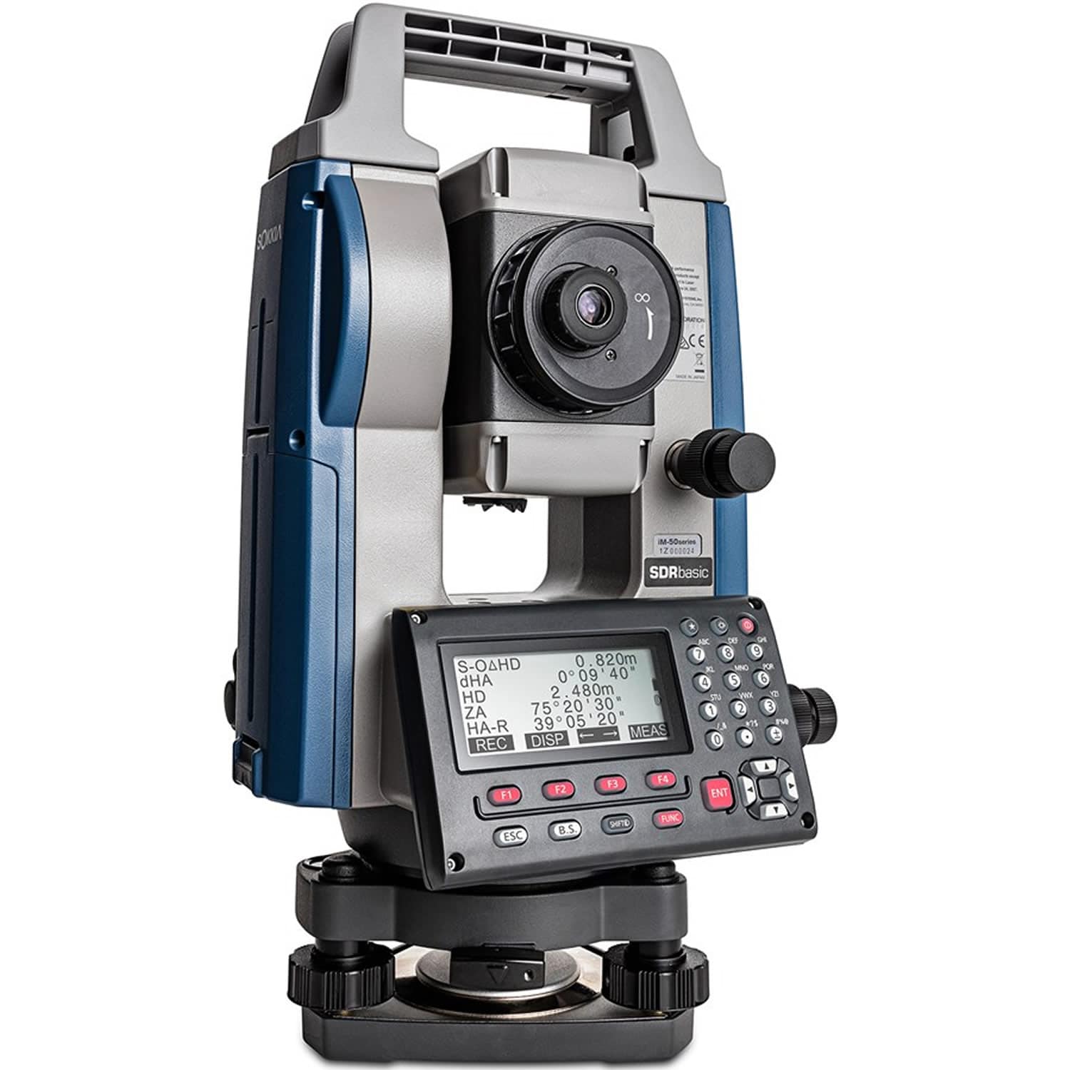
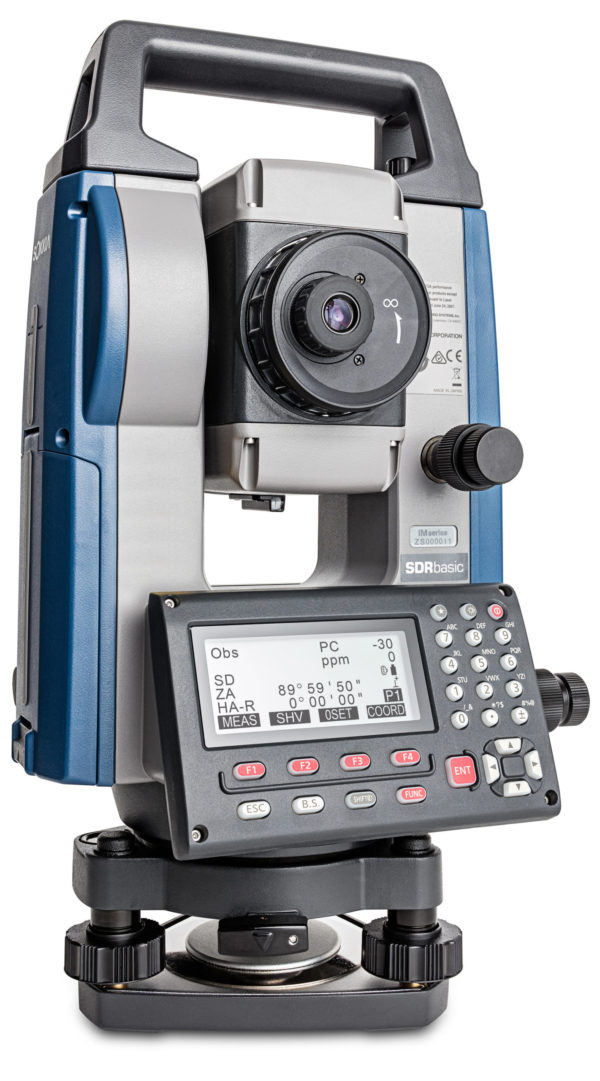
Key Features of Sokkia IM105/Sokkkia IM101 Reflectorless Total Station
With Sokkia IM-105 Total Station /Sokkia IM-101 Total Station you get fast, accurate, and powerful EDM technology, best-in-class accuracy up to 6,000 meter with a prism and up to 1000 meter in reflectorless mode, and a battery life of up to 28 hours. The iM-100 series intelligent measurement station is ready to be your hardest worker out in the field.
Construction and Survey Application Software Reliable All-Round Total Station
Cross-Sectional Survey
By using the MLM (Missing Line Measurement) program, the height difference between points can be calculated. Also, you can save time on reflectorless mode to measure a number of points of variation in a large area.
Stake Out
The Guide Light function will navigate the prism operator to move to the stake out line quickly so that stake out operation can be done effectively.
Elevation Stake
Staking out with 3D coordinates, eliminates the need to set up TS on the straight line for all elevation stakes.
Boundary and Cadastral Survey
By using the Area function, you can calculate the area easily. Also, you can determine the center point of the column such as electric pole, which cannot be directly measured, by using offset calculation.
Coordinate Measurement
With coordinate measurement, you can manage 3D coordinate data so that various calculations such as Road, Layout and more can be determined. 3D coordinate data management can improve the productivity drastically.
Topographic Survey
The trigger key, or measuring distance key, helps you perform topography quickly while continuously viewing through the telescope. Also, the long distance measuring range reduces the number of the instrument changes for more efficient working time.
Improve Topography and Stake Out, with features to achieve faster and more efficient workflows
IoT Support System – Connect the Site and the Office
TSshield IoT Support System
- Remotely update the firmware via the internet
- Improves asset management by checking TS operating time
- Remote Lock secures the instrument from theft.
- Monitor TS heath status to enable quick reaction against any functionality issues
Superior Basic Feature will Expand Your Application
Strong Environmental Spec
The IP66 rating ensures durability for most any rough job site temperatures and conditions.
Long Hours Operation
One battery lasts up to 28 hours, or about four days of normal operation time.
Bright Illumination Key for Nighttime Work
Key buttons are illuminated to minimize mistakes.
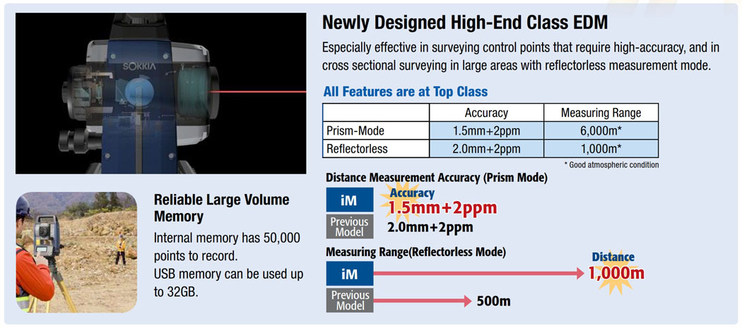
Reliable Large Volume Memory
Internal memory has 50,000 points to record.
USB memory can be used up to 32GB.
Japan Quality Products
We perform the tough environmental tests to ensure long-term operation even under the rough site environments. Sokkia iM 100 Series total stations are thoroughly inspected with dust-proof and water-proof test chambers.
In addition, the various tests against vibration, drop, temperature, and humidity were successfully passed to achieve the best environmental spec. Also, the measuring distance accuracy test on base line and the instrument leveling and angle accuracy test and adjustment by collimator system ensure your satisfaction on iM Series product quality.
Sokkia Total Station, Model IM-55
The Sokkia iM 55 Total Station is the perfect entry-level site layout and survey tool offering reliability and flexibility without sacrificing cost or functionality. The Sokkia iM 50 Series Total Station’s sleek design is built tough, with a water and dust-proof IP66 rating, integrated Bluetooth® capability and an internal antenna, enabling you to deliver measurements cable-free to your data controller, streamlining your equipment weight and workflow.
Sokkia iM-55 Reflectorless Total Station is also armed with a top line EDM, generous internal memory storage, and SDRbasic on-board software so you have everything you need to get the job done out in the field.
Feature:
- 5″ Accuracy, Fast distance measurement of 0.9s..
- Reflectorless operation from 30cm to 500m.
- 50,000-point internal memory
- Upto 32GB USB Pen Drive Support
- Coaxial EDM beam and laser-pointer provide fast and accurate aiming.
- Ensures accuracy even with reflective sheets.
- IP66 dust-proof waterproof rating.
- Rugged metal chassis and heavy duty handle.
Sokkia High Precise Digital Level, Model SDL-1X
The Sokkia SDL1X Digital Level is designed to achieve the highest precision and productivity in leveling and height measurement applications. From Intelligent Auto Focus to wireless operation, a number of innovative technologies are implemented for unmatched reliability while eliminating error factors during measurement.
Features:-
Saving measurement time by up to 40 % |
Seamless switching between Autofocus and Manual |
View Finder for quick sighting. |
Intelligent Auto Focus |
Remote Trigger |
Dual-Axis Tilt Sensor |
Measurement and recording programs |
Up to date data memory and interface |
100m(320 ft) Bluetooth Wireless Modem (Optional) |
New super-invar staff for 0.2 mm precision |
Sokkia Digital Level, Model SDL-50/SDL-30
Features : High-Speed Measurement : Aim, focus and press a key. Height and distance asre simultaneously measured in 2.5 seconds, 20% faster than ordinary digital levels.
Consistent Performance : ADL30/SDL50 provides superior measurement capability under variety of environment conditions. Even when the staff surface is partially shaded, or brightness at staff surface is as low as 20 lux*, SDL30/SDL50 consistently provides reliable measurement results without downtime.*20 lux is the minimum brightness required to recognize human face.
Automatic Recognition of Inverted Staff : SDL30/SDL50 automatically recognizes directions of RAB-Code staffs and displays the results with a minus sign (-) when the staff is inverted.
Wave-and-Read Technology : Innovative “Wave-and-Read” technology provides an additional survey style option. SDL30/SDL50 tracks the RAB-Code staff waved back and forth to read the correct height. The least value of the staff readings is automatically detected.
Height Accuracy :
SDL30 : 0.4mm (BIS30A – Super-Invar) / 0.6mm (BIS20/30-Invar) / 1.0mm (BGS-Fiberglass)
SDL50 : 0.6mm (BIS30A – Super-Invar) / 0.8mm (BIS20/30-Invar) / 1.5mm (BGS-Fiberglass)
GeoFennel Automatic Level, Model GFN-10
- 32 x magnification and bright optics
- Robust all-metal housing
- Wedge-shaped reticle
- Internal circle and compensator test button
- Handle for comfortable handling
Features
- Robust metal housing with handle for comfortable handling
- Reticle in wedge-shape for most accurate reading
- Well protected internal circle
- Compensator test button
- Bubble reading mirror
GeoFennel Auto Level, Model GFE32
GeoFennel Auto Level, Model GFE-32 is 32X Highly precise Automatic Level. This is the German Engineering at an afffordable prices.
Sweden’s GPS company Satlab joins hands with PIE
SatLab Geosolutions is a Swedish global satellite positioning solutions company with offices strategically located around the world. It was founded by a group of passionate and pioneering engineers, with a total of more than 40 years of experience in the GNSS industry. In the geospatial world, surveying professionals depend on the most accurate and precise measurements to build the world we live in. At SatLab offers solutions with cutting-edge Swedish engineering and technology.
Satlab has appointed PIE as it’s authorized distributor in India.