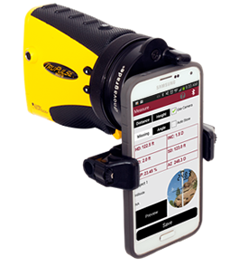
T&D Pro Overview
LTI’s touch-screen activated, easy-to-use T&D Pro Field Software along with our reflectorless laser measurement technology makes getting the measurements you need quicker, easier and safer. Verify the sag and tension of multiple power lines, conductor’s clearances, attachment heights and even the direction for a guy wire. The step-by-step graphical aids and instructions were written for non-surveyors, making transmission and distribution tasks a snap. No need to drag around measuring wheels, height sticks or bulky, expensive total stations, just grab a TruPulse laser integrated with T&D Pro software and you’re ready to hit the field!
Instantly calculate critical values and data on the spot, you no longer have to wait to get back to the office. Electronically record and store field data and you can create professional reports and graphs with minimal effort.
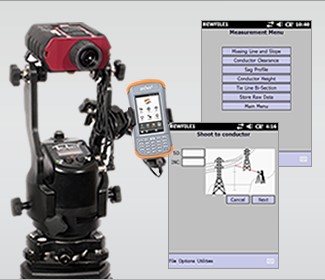
T&D Pro Features / Functions

Missing Line & Slope
Applications: To measure span lengths, vegetation clearances, remote slopes and changes in elevation.
Solutions: Follow the step-by-step procedure for shooting in any two remote points, and T&D Pro will instantly calculate the azimuth, inclination and slope distance, as well as measure the horizontal and vertical distance between those two points.

Conductor Clearance
Applications: To determine if a tree is in danger of hitting a conductor if it were to fall.
Solutions: Position yourself either under the conductor or at the tree in question. Measure the tree height and then shoot to the conductor. T&D Pro provides the line clearance value. If it is negative (-), mark the tree to be cut.

Sag Profile
Applications: To verify the span, sag and tension of a conductor.
Solutions: Take multiple shots along the conductor, including both attachment points. In addition, you can map in the ground beneath the span and any other obstructions in the way. T&D Pro instantly calculates the span, sag and tension values for the conductor. It even calculates the height and location of the lowest point.

Conductor Height
Applications: To calculate a conductor’s height aboveground or some other point of reference.
Solutions: Using any of the four measuring methods will always yield an accurate value. Shoot at a point along the conductor and then to a spot below it. T&D Pro instantly displays the height of the wire.

Tie Line Bi-Section
Applications: To locate the direction in which to anchor the guy wire at a bend point in a new line.
Solutions: To determine the direction necessary to anchor the guy wire at a bend point in a new line, occupy the bend point and measure azimuths along both routes. T&D Pro solves for the needed direction.

Store Raw Data
Applications: Logging miscellaneous distance, angles, heights, etc.
Solutions: You can log miscellaneous distances, angles, heights and other data simply by shooting to an object and sending the data string to T&D Pro. Notations can be stored along with the data.
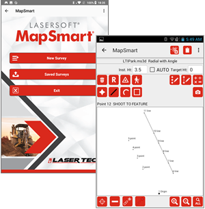

 MapSmart Measuring Stockpile Volume
 Measuring with MapSmart and the TruPoint 300